Discover how OpenSpace can modernize your site tracking and collaboration.
Seamlessly collaborate, streamline site documentation, optimize field productivity, and dynamically track progress to elevate your projects.
Transform your construction site into a fully navigable digital environment. OpenSpace uses AI and 360° video to automatically map your job site, enabling teams to monitor progress, identify issues, and collaborate remotely, without being physically on-site.
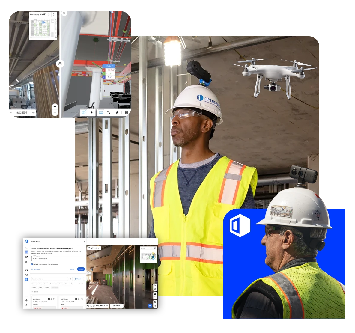


See everything happening on your jobsite. In one platform. It’s a snap to capture how you want, with smartphones, 360° cameras, drones, and laser scanners.
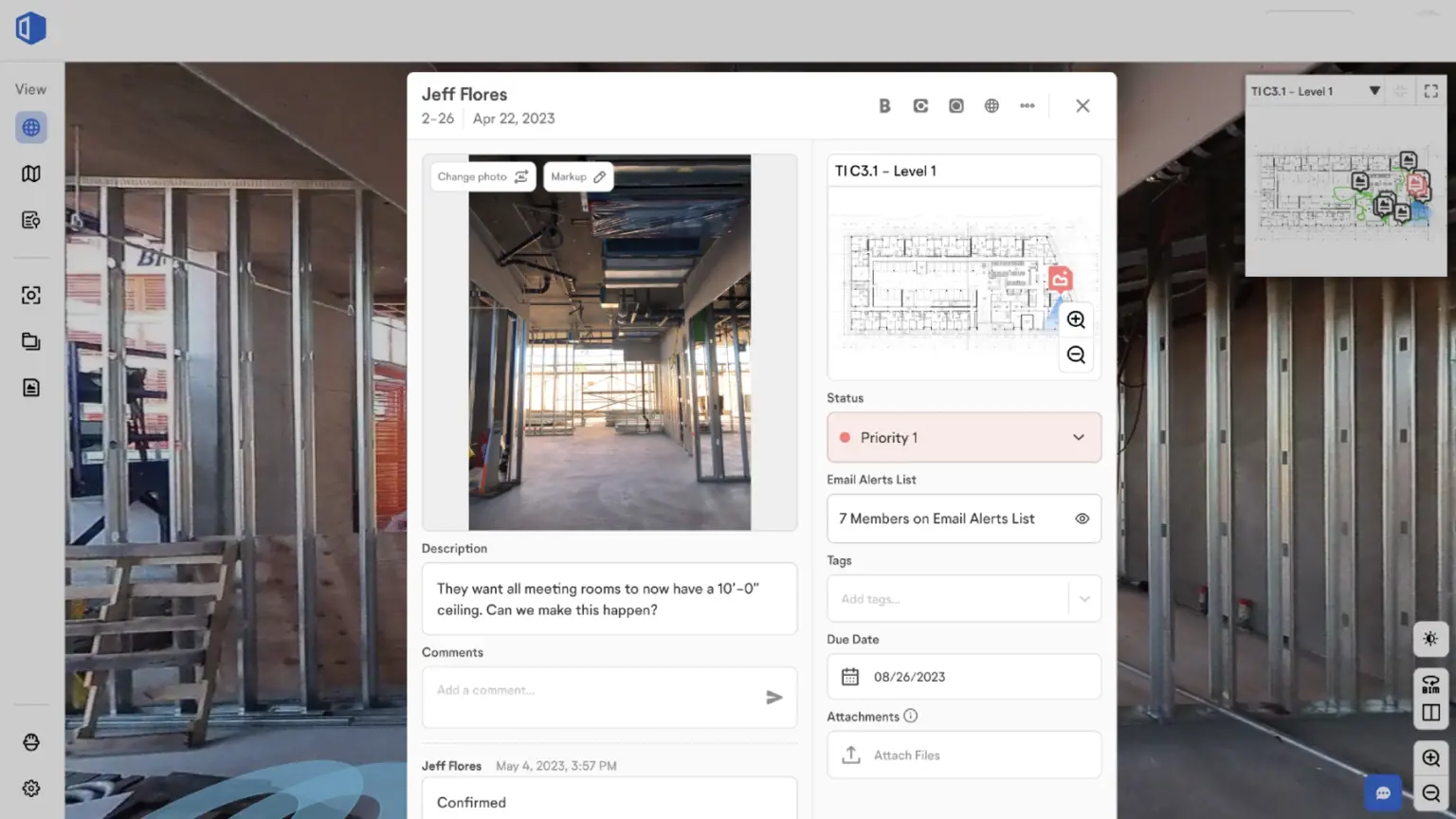
Your captures, timestamped and mapped to your plans and BIM, automatically. Add your expert insights on the spot, even with just your voice. Make better and faster decisions.
Now all your teams can work as one team. With Visual Intelligence on every smartphone you can keep the job moving. Plus OpenSpace integrates with tools you already use to fit right into your flow.
See why modern construction teams trust OpenSpace to modernize their project tracking.
Stop snapping thousands of photos. Simply walk your site with a 360° camera, and our AI automatically maps and pins every video frame to your floor plan in the background.
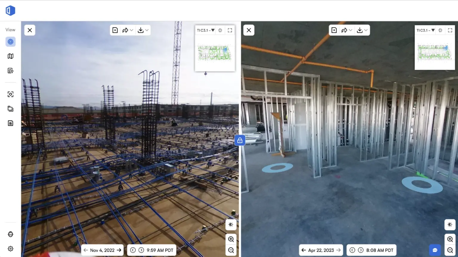
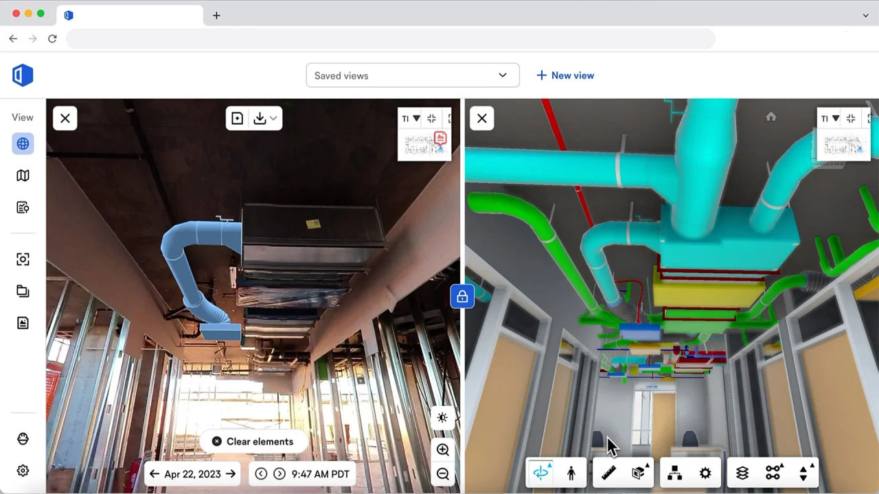
Create an indisputable, timestamped digital twin. Use Split View to “travel back in time” and verify work behind walls without destructive investigation, preventing liability claims and costly delays.
Give stakeholders a “Google Street View” experience from anywhere. Owners and architects can virtually walk the site to track progress and approve work without travel, speeding up decisions.
OpenSpace empowers General Contractors, Owners, and Specialty Trades to capture a complete visual record of any project, faster than ever before. It allows teams to track progress remotely, verify installation against BIM models, and spot issues instantly. By replacing manual photo-taking with passive 360° video, OpenSpace helps you build with total transparency and prevent costly delays.
Start documenting your jobsite instantly with AI-powered tools that do the work for you. Capture 360° video, track progress, and spot issues automatically, without manual data entry.
Hands-free documentation. Automatically record every angle just by walking the site.
Zero manual pinning. AI maps video to floor plans automatically in 15 minutes.
View current conditions side-by-side with previous dates to see behind closed walls.
Snap photos of defects that automatically pin to the correct location on plans.
Record walkthroughs entirely offline and upload data later when back in the office.
Use iPhone or iPad to create detailed 3D LiDAR scans of critical areas.
Overlay 3D BIM models onto reality captures to spot clashes or errors instantly.
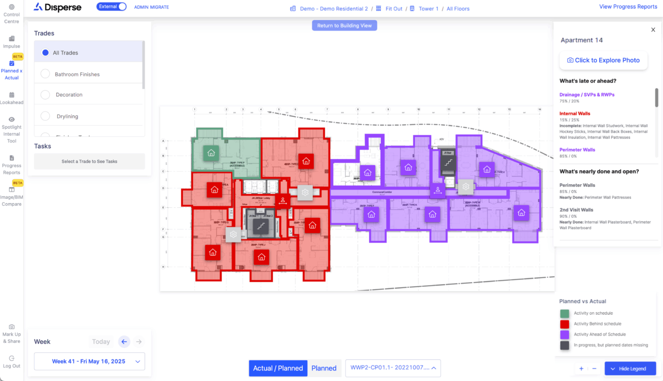
AI analyzes images to automatically track quantities for key trades like drywall.
See exactly where you’ve walked on the floor plan with clear path lines.
Create shareable links for stakeholders to view specific site areas without login access.
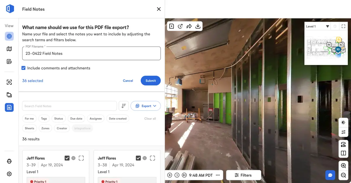
Seamlessly sync with Procore and Autodesk to turn Field Notes into RFIs automatically.
Enable owners to remotely "walk" the job site from anywhere in the world.
As the authorized local partner for OpenSpace, GFT delivers more than just software. We ensure your reality capture implementation is seamless and scalable.
Specialized advice on camera hardware selection to optimize performance and capture quality for your specific projects.
Full system setup and training to ensure your team can capture, upload, and navigate the platform immediately.
Ongoing technical support across the GCC and Egypt, ensuring smooth and scalable deployment for all your clients.
How It Works: From Setup to Success. We don’t just sell software; we partner with you to transform your entire site documentation workflow.
Get expert answers tailored to your digital transformation. We ensure OpenSpace fits your construction monitoring and documentation workflow perfectly.
See the AI in action. Experience how OpenSpace automatically maps 360° video to your floor plans and identifies issues in real-time.
As the regional partner, we provide scalable solutions that match your team size, project volume, and hardware requirements.
No IT headaches. Since OpenSpace is cloud-based, we handle your project setup and integrations so your team can start capturing immediately.
We empower your team with specialized training on 360° capture best practices and platform navigation to ensure 100% adoption from day one.
Ongoing technical support from our experienced engineers, ensuring your continued success with automated progress tracking and remote collaboration.
Discover how OpenSpace can modernize your site tracking and collaboration.
OpenSpace is a construction reality capture platform that turns site walks into a navigable, visual record mapped to your plans for progress tracking and collaboration.
You record a 360° video walkthrough during a normal site walk, and OpenSpace automatically aligns the capture to your floor plans using its AI mapping technology.
Captures are processed quickly so teams can review the jobsite soon after the walk, often around 15 minutes on average.
You can capture even without an internet connection, and the platform can upload in the background once a connection becomes available.
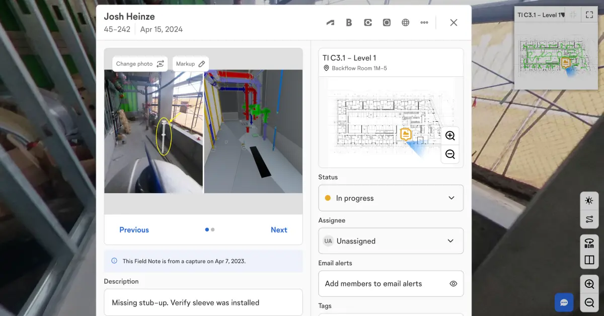
Field Notes let you add photos and comments that are pinned to a specific location on the floor plan, making issue tracking and communication easier.
es, features like Split View let you compare the same location across different dates, supporting progress checks and documentation before areas get covered.
OpenSpace supports integrations, including workflows connected to Autodesk Construction Cloud, to reduce duplicate work and keep project data aligned.